


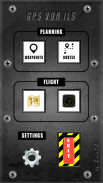

VOR ILS GPS
Deskripsi VOR ILS GPS
This application is NOT CERTIFIED to be used FOR FLIGHT GUIDANCE.
Use only in Visual Meteorological Conditions.
Do not use as single source of guidance.
The developer is not responsible for damage resulting from incorrect usage of this application.
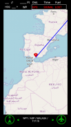
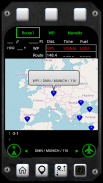
- You must define a reference point: VOR, ADF, NDB, or the touchdown point of a runway.
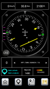
- The Horizontal Situation Indicator will provide indications to this point.
- The green arrow indicates the heading to the reference point.
- If the reference point is the touchdown point in a runway, the HSI will provide also indications to fly a 3º glideslope to that point (simulating an ILS approach).
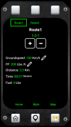
- Choose the course you want to follow. The Course Deviation Indicator will diplay a deviation up to 10º each side of the selected course.
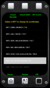
- The reference point must be defined introducing its coordinates and gps altitude. You can introduce up to 20 waypoints.
- You can save the coordinates of your current position by pressing the Mark button and importing them as a new waypoint.
Example:
N 40º 22' 12.92"
W 003º 46' 36.4"
Connect the location sensor of your device.
The information provided during the first two minutes (mainly the altitude data) will not be reliable.
Warning: Some devices do not provide gps data when in battery low mode.
Aplikasi ini TIDAK BERSERTIFIKAT untuk digunakan UNTUK PENERBANGAN PEDOMAN.
Gunakan hanya di Visual Kondisi Meteorologi.
Jangan gunakan sebagai sumber tunggal bimbingan.
Pengembang tidak bertanggung jawab atas kerusakan akibat dari penggunaan yang salah dari aplikasi ini.
- Anda harus menentukan titik acuan: VOR, ADF, NDB, atau titik touchdown landasan pacu.
- Indikator Situasi Horisontal akan memberikan indikasi ke titik ini.
- Panah hijau menunjukkan judul ke titik referensi.
- Jika titik acuan adalah titik touchdown di landasan pacu, HSI akan memberikan juga indikasi untuk terbang 3º glideslope ke titik itu (simulasi pendekatan ILS).
- Pilih kursus yang ingin Anda ikuti. Indikator Course Deviation akan diplay penyimpangan hingga 10º setiap sisi saja yang dipilih.
- Titik referensi harus didefinisikan memperkenalkan koordinat dan gps ketinggian. Anda dapat memperkenalkan hingga 20 titik arah.
- Anda dapat menyimpan koordinat posisi Anda saat ini dengan menekan tombol Mark dan mengimpor mereka sebagai waypoint baru.
Contoh:
N 40 º 22' 12,92"
W 003º 46' 36.4"
Hubungkan sensor lokasi perangkat Anda.
Informasi yang diberikan selama dua menit pertama (terutama ketinggian data) tidak akan dapat diandalkan.
Peringatan: Beberapa perangkat tidak menyediakan data gps ketika di baterai modus rendah.
VOR ILS GPS - Versi 4.0
(24-03-2022)VOR ILS GPS - Informasi APK
Versi APK: 4.0Paket: appinventor.ai_bolo122.GPSVORILSVersi Terakhir dari VOR ILS GPS
Versi lain


Aplikasi pada kategori yang sama

Anda juga mungkin suka...
Aplikasi pada kategori yang sama


